compiled by Janice Calcei
referring extensively to the book “Burekup – On the Henty” 2000
Updated: 17 June 2025
Quick Links:
- European Exploration
- The Nyoongar People
- Early Settlers and Agriculture at Burekup
- Burekup Townsite and Buildings
- Highland Valley and Ventonia
- Agriculture in the 20th Century
- Charles and Rachel Hill
showing he traversed areas later known as Burekup, Ferguson and the Preston Valley.
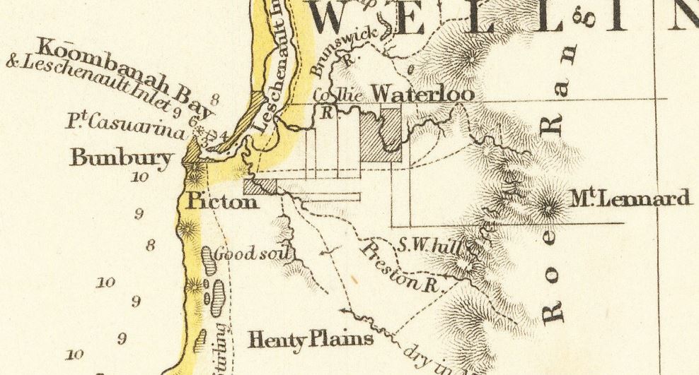
European Exploration
Europeans first ventured into the land to the east of Bunbury between 17 and 20 November 1829, when Dr Alexander Collie and Lieutenant William Preston spent time exploring the Leschenault Estuary and the mouths of what were soon afterwards named the the Collie and Preston Rivers.
The following year, between 3 and 16 March 1830, John Septimus Roe (Surveyor General) was accompanied by interested settlers on another expedition through the areas now known as Waterloo, Burekup, the Ferguson Valley, Crooked Brook and the Preston Valley. Among others, the party included Dr Alexander Collie, Lieutenant William Preston, Lieutenant Governor James Stirling and James Henty (representing the Henty brothers who went on to established agricultural enterprises in Victoria and Tasmania).
James Henty commented to his father in a letter soon after the journey with Roe, and others, on the apparent lushness of the land as potential grazing ground for sheep. He applied for a government grant of 69,000 acres which he received in 1830. It was the second largest in the Leschenault District after the 103,000 acres of Colonel Peter Augustus Latour. In January 1831 Henty returned with William Shenton to inspect the land again. His earlier opinions of its high quality were confirmed (Staples, p 32), however within a few years the Hentys abandoned their grant and moved on to other interests in the eastern colonies.
The Nyoongar People
Roe commented in a report written shortly after this journey: “It is somewhat remarkable that throughout this excursion of about 50 miles we saw no natives, although the traces of them were evident and numerous in many places and we passed several of their old deserted habitations, which were of the usual temporary constructions of boughs and grass.” The Nyoongar people who lived in all these areas would decline in number throughout the 1800s as access to food sources was cut off by land grants and farming, and as diseases brought in by settlers took a devastating toll. The decline continued in the 1900s as a result of government policy limiting where first nations people could live and work and removing children from their families. And yet Nyoongar people continued to live in and around the Dardanup area in camps at Burekup, Brick Hill (between Burekup and Waterloo) as well as at Picton and at the nearby Roelands Mission.
Early Settlers and Agriculture at Burekup
Further agricultural development around Burekup stalled following the departure of the Henty brothers. It was not until the late 19th century that farming began in earnest.
When the Perth to Bunbury railway opened in 1893, a railway siding was established at Burekup including a station building and goods shed. The siding also had cattle yards and loading ramps. The siding provided convenient transportation for local produce – mainly grains, citrus fruits and potatoes – which were sold in the surrounding areas and also in Perth. By the 1920s, the Burekup siding was responsible for transporting huge quantities of produce along the Bunbury to Perth railway, and a station master was also employed.
Burekup depended entirely on the train until the end of WWII, and the sound of the train whistle and the comings and goings of the trains and the produce they carried was a source of excitement and importance to the local community. When the railway closed, eventually the infrastructure was removed, leaving behind the railway line and a fig tree.
An 1897 Crampton family diary suggests the Cramptons were one of the earliest families to settle following the Henty’s departure to Tasmania. Other early settlers were the Clarke, Piggott, Rose, Winduss and Muldoon families.
Boongarra homestead, on South West Highway and Orchard Road, is one of the earliest homesteads constructed in the Burekup district. Charles Clarke, who was born in Bunbury in 1883, one of ten children, purchased the property in 1905. At 16 years of age Charles had left school to assist his father on the farm at Roelands and six years later at the age of 22 he purchased 40 acres across the Collie River, later enlarging it to 300 acres, which became Boongarra. The homestead was built by well-known local builder, Mr Rafferty in 1907.
Charles Clarke and his family were renowned for successfully establishing a retail business which dealt with leasing and purchasing farm machinery, seed potatoes, manure and other items, making it convenient for farmers to hire ploughs and horses locally. This business also marketed the potatoes and other produce including citrus fruit. He and his family also grew pears, apples, oranges, lemons, and mandarins, had cattle and grew clover commercially. The Clarke business collected clover seeds, cleaned and tested them. Their large estate required a significant staff of farm workers, and the family is remembered as generous providers for its workers and their families, even providing cottages for them close to the farms on which they worked.
Before the 1920s, heavy labour at Burekup was carried out with the help of horses. Timber for houses and sheds was transported via the railway from outlying timber mills. Once at the station, timber was loaded onto horse-drawn wagons and carted to various destinations. It was not until the 1920s that trucks began to appear.
Land clearing was a slow and arduous task involving constant burning of vegetation. Explosives were used to remove ground rocks and tree stumps. Trees were felled either by a hand axe and pick or by ring barking. This involved a ring being chopped around a tree trunk, to suffocate its growth. Cattle would then be encouraged to feed on the new growth sprouting below the ring, preventing regrowth. Trees were uprooted by men’s sheer brute force or removed with the help of horses.
Burekup Townsite and Buildings
In 1911, the residents of Burekup who had school age children signed and presented a petition requesting the construction of a school in the district. At this time, the nearest school was five miles away. Two years later, on 29 January 1913, a school was opened in Burekup. The school was provided with one teacher and was attended by twelve children though no purpose built classroom was constructed at the time. It is not known where the school was housed when it first opened, but temporary accommodation provided by the community was not uncommon at this time.
Land was set aside for a school reserve at Burekup in February 1914. Public Works Department of WA drawings indicate that the new school building was a single roomed weatherboard and corrugated iron building with a partially enclosed verandah. The provision of good ventilation and light is evident through the design of 14 feet ceilings with vents and windows to ceiling height on either side of the classroom. The new school building was opened on 4 May 1914. In 1951, plans were drawn up by the PWD for weatherboard and corrugated iron additions with some alterations to the existing classroom which were completed by 1952. Additional buildings/sheds were added to the school site and the shelter shed was enclosed and had a pergola added to it.
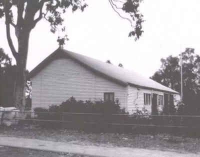
The original Burekup School was closed in 1997. Although it was assessed by the Heritage Council WA for the State Register as part of the Government Heritage Property Disposal Process (GHPDP) it was assessed as below threshold and not listed by them. Subsequently the original buildings were demolished, mainly owing to termite damage. The initial proposal was to not to rebuild the school and to bus students to Bunbury. Owing to strong community lobbying, a new school was built and opened in 1999 and named River Valley Primary School.
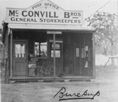
The Burekup Store was built in 1914, by Frank and Ernest McConvill. It was originally a timber single storey store and residence and also housed the Post Office. The McConvill’s also built a men’s club, located between the school and hall. The store was sold in 1921 to J Bradford for £650.
In the same year, the Burekup Hall was brought down from Worsley on the train and re-erected on its present site. It became a popular venue for dances. Originally it was lit by kerosene pressure lamps which hung from the roof trusses on wire hooks. It is thought to have originally been of timber construction with an iron roof. In the 1940s the hall was connected to electricity via an electricity plant driven by a Rushton Hornsby engine. It was connected to State Electricity Commission (SEC) power in the 1950s. In the 1960s the hall was brick veneered, re-roofed, re-floored and a stage built. New septic toilets were added. These additions and modifications provided more modern kitchen, storage and office/clubroom facilities and increased the activity and usage including for the Burekup District Country Club.
St. John the Divine Anglican Church was built at Burekup in 1938. The church was built by Mr Percy Hough of Bunbury to a design by Mr George Herbert Parry, architect. The church was consecrated in 1937 by Bishop Lesley Knight of Bunbury and opened on 24th April 1938. The church is associated with the local family, Mr and Mrs GC Money, whose generosity made the building of the church possible.
The Burekup CWA (Country Women’s Association) was established in 1947. By 1957, they had built their own hall which was officially opened by Mrs Ida Spencer (CWA State President) who cut the ribbon. Hazel Gardiner (nee Jarvis), who had moved to Burekup after her marriage (Allan Gardiner) was instrumental in establishing the Burekup CWA, was a founding member and Branch President at the time the hall was built.
Highland Valley and Ventonia
W S Hedges sold Highland Valley to Gus Behn, a German butcher, in the early 1930s. Behn continued to develop the gardens and infrastructure and was very fond of throwing grand tennis and garden parties. Behn sold to Bill and Heather Prowse in the early 1950s. They raised beef cattle and grew potatoes on the fertile river flats. They gradually sold off parcels of land down to the homestead title which was then purchased in 1978 by Taylor, a wheatbelt sheep farmer who needed sheep yards and holding country closer to Bunbury. The homestead was rented out and was in desperate need of maintenance and repairs. The property was sold again to John White in 1982. John and his son Oren would travel down from Perth on weekends doing long overdue maintenance and watering. Oren White purchased the property in 1994 and began major upgrades to power and water before commencing the stable conversion to a residence.
Ventonia homestead on Rose Road in Burekup, was built in 1928. It was the home of Tom and Dorothy (nee Wilson) Rose and their five sons. The Rose family’s greater property, upon which Tom’s property Ventonia was located, stretched along both the Burekup and Roelands borders with Henty Brook separating the two halves. When first married, Tom and Dorothy lived in the original timber weatherboard cottage. The new brick homestead was only partially completed when Tom Rose was killed when his car hit a train at the railway crossing at Burekup siding in December 1927. Dorothy lived on at Ventonia, raising her sons. Tom had been a successful farmer, raising a dairy herd, pigs and lamb as well as growing potatoes, fruit and peas. He was also a partner in the large clover seed cleaning enterprise in Clarke Street Burekup.
Click here to see further information about Burekup and Henty Houses & Homesteads.
Agriculture in the 20th Century
Up until the early 1930s farmers primarily established orchards and paddocks of potatoes. The continuous crops of potatoes were the choice produce at the time and were the most profitable. One of Burekup’s earliest settlers, Mr Crampton, was also one of the first potato farmers, his Delaware crops reportedly the first in the region. Land surrounding the Collie and Henty Rivers was transformed into productive paddocks by constant clearing, digging, ploughing and planting. Farm labour provided employment for new arrivals in town seeking work. Some farmers prided themselves as good ploughmen with a two horse team and a robust Massey No 10 plough. Before the introduction of superphosphate, growing grass, potatoes and even establishing orchards was hampered by the soil’s acidity.
In about 1935 the Public Works Department used a large steam driven dragline to dig the Victory drain at Waterloo and the Valiant at Burekup. Both were designed to drain off excessive water as some winters the rainfall reached 1000 millimetres. The area at Burekup was drained near Paradise on Dowdell’s Line through the Ladysmith Plains to the Collie River with Waterloo drained from Paradise, Dardanup Road to the railway down to Millars Creek.
This was a huge undertaking, with an enormous dragline weighing up to 80 tons railed down, where it then had to be assembled. This task took three months. Mr Bob Tyrell recalled those times saying that mostly boggy land meant moving the machine with horses was a slow process. Another memory was from Mr John Hutchinson who saw the machine operating. “The wood to keep the boiler going was cut by George Tyrrell and stacked in dumps along the route, ” he said. “The water needed for the machine was carted by Mr Paddy Harnett and his boys in what we believe was his old Thornycroft truck, a vehicle which ran on solid rubber tyres.”
The water was pumped into the machine by a hand pump and the dragline, known as the ‘Steam Navvy’, made its way to Paradise along the Victory drain, over to the Dowdell’s Line where it dug its way down to the South West highway as the Valiant drain. Despite initial problems with the dragline and horses completing the north west side, the dragline was an important cog in the farming wheel of progress. Once the flat land was drained farm production increased dramatically.
Charles and Rachel Hill
In the 1950s, Charles Hill, his wife Rachel (nee Abraham) and children moved from Pingelly, where they owned land, back to Burekup to be nearer family. Descendants of this Nyoongar family now comprise much of the aboriginal population of Bunbury. The Hills camped for a few months at Kelly Road in Roelands, then were offered Clarke’s dairy shed and finally a campsite on a local farmer’s land near the Collie River. There was no electricity or running water.
“Through the summer months, Charles and his family would work the farms between Burekup and the coast, carting hay, planting and picking potatoes (‘spuds’) and doing general farm work. They would also do stone and stick picking, clearing paddocks for farmers by hand.
They spent all of their spare time, mainly on weekends, as a family down at the mouth of the Collie River, on the south bank of the river just as it meets the Leschenault inlet. This was a special place for the whole family and still is today. The estuary is where the family camped under the stars and lived on seafood for days at a time.
This pattern of movement that led the family down to the estuary during the summer months followed the same patterns as Charles Hill’s ancestors, who had followed this mobility pattern as part of their traditional hunter-gatherer traditions.” (The Gravel Pit – our stories, 2017, p. 4).
The children went to school at Burekup and later at Waterloo. Charlie Hill died in October 1966 and was remembered as the “King” of the Burekup aboriginal community “A great leader and a man we will never forget” (South Western Times, 27 October 1966). Rachel and her daughter and son-in-law moved to two state-owned houses near Waterloo in the late 1960s and others in the family moved with them or began to find homes in Bunbury at this time.
References:
- Burekup – On the Henty, by the People, Western Australia, 2000.
- Schoobert, J. (Principal Editor) Western Australian Exploration – Volume 1, December 1826 – December 1835 (2004) covering the following three records:
Preston, William; Observations on the coast &c from Cockburn Sound to Geographe Bay between 17 and 20 Novr 1829 by Mr Collie and Lieut Preston, pp. 95-103
Roe, John Septimus; Government Notice – Exploration of the Collie and Preston Rivers, March 22, 1830, pp. 152-156
Henty, James: Journey South on the Eagle, March 20, 1830, p, 17-158 - Staples, A C; They Made Their Destiny – History of the Settlement of the Shire of Harvey 1829-1929 (1979), Shire of Harvey, Western Australia.
- Shire of Dardanup, Local Heritage Survey, November2016 – Final, https://www.dardanup.wa.gov.au/wp-content/uploads/sites/105/2014/05/LHS_2016_final-issue_November_2016.pdf. Accessed online on 12 December 2021
- The Gravel Pit – Our Stories – Community Arts Network (2015) Perth, Western Australia.
Newspapers:
- Charlie, ‘King’ of Natives, is Dead, South Western Times, Oct 27, 1966.
Map source:
- Arrowsmith, John; Segment of map of The Colony of Western Australia; From the Surveys of John Septimus Roe Esqr. Surveyor Genl. And from other Official Documents in the Colonial Office and Admiralty . . . 1839, https://www.raremaps.com/gallery/detail/74352/the-colony-of-western-australia-from-the-surveys-of-john-s-arrowsmith, accessed 28 January 2022.
