by Jenny Trigwell & Janice Calcei
Updated: 29 June 2025
Quick Links:
A water problem solved
During the 20th Century irrigation channels and large drains became a common sight and were an accepted support for agriculture in the Shire of Dardanup, but when and how was this enormous project delivered?
Many early settlers around Dardanup, Waterloo and Burekup owned low-lying poorly drained farmland which flooded in winter. In summer water for cropping and livestock was scarce and not cheap or easy to access. In the 19th and early 20th centuries farmers grew fruit, oats for chaff making and potato crops planted in swamps during summer. They raised cattle and sheep, moving their livestock between inland and coastal locations.
Drains were needed to remove excess winter water and a user pays irrigation scheme needed to deliver water during dry periods. Nearby Bunbury too needed a reliable domestic water supply. The Bunbury-Roelands Irrigation and Water Scheme was the proposed solution. Large drains were also to be constructed in Waterloo.
Meetings were held across the region beginning in the early decades of the 20th Century and the State government was lobbied on multiple fronts by farmers, businesspeople and local Roads Boards (Councils).
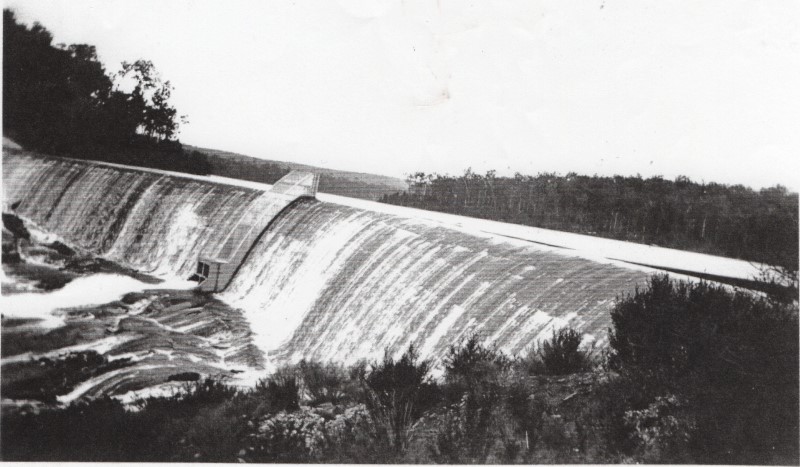
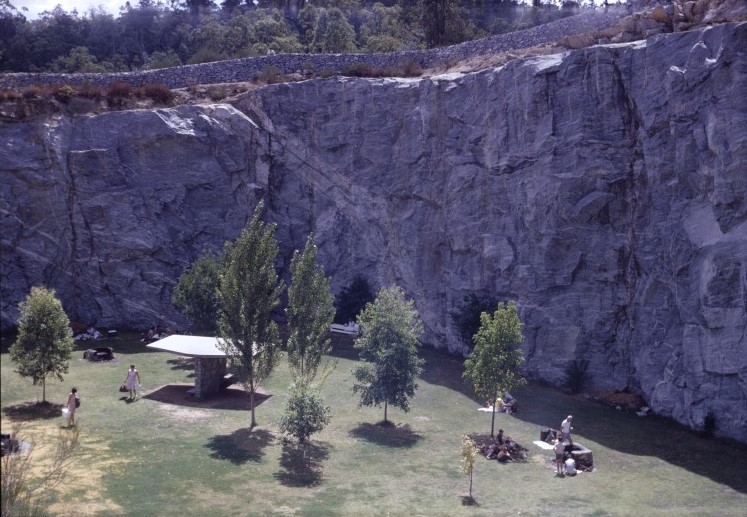
In 1933 Wellington Dam was constructed to a height of 19 metres as the headworks for what became known as the Collie Irrigation District, once one of the largest users of water for irrigation in Western Australia. The dam wall was raised a further one metre in 1944, and 15 metres to its current height of 34 metres, between 1955 and 1960. It is the only example in Western Australia of a combination of water supply facilities for irrigation, domestic use and hydroelectric power. After 1960, the site became important for recreation when a picnic area combining natural vegetation and landscaping was designed by John Oldham at the old stone quarry above the dam.
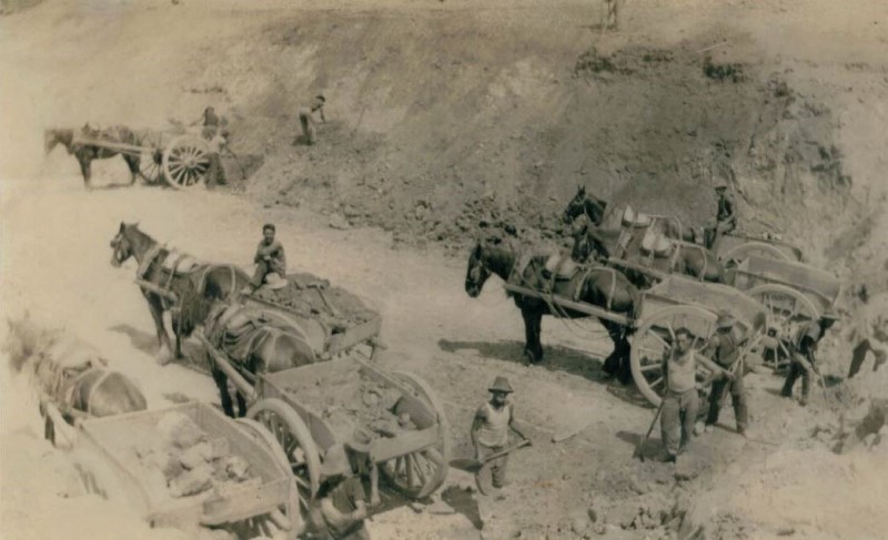
Irrigation channels were surveyed between 1932 and 1934. During the Great Depression years of 1929 -1939, men were employed to dig the channels and erect bridges by hand with picks, shovels and mattocks. City workers moved to the country to find employment in return for food and housing. Italian migrant men were also employed, camping at the old Dardanup Agricultural Hall.
Workers were paid to dig one chain, about 20 metres, each week. An easy task Italians migrants, who completed their allotted section in three days and used the rest of the week to clear land for farmers. White-collar workers found it harder going and would spend a whole week digging theirs.
Domenic Garbelini (from memoirs provided by Tom Garbelini)

Source: Margaret Vinci
The Burekup Weir was built to divert water into the open channels of the irrigation network.
The first water from the Collie Irrigation Scheme was mentioned in the Fee Diaries as arriving at Dardanup in January 1935, and is shown here arriving at Fir Park, Waterloo in February the same year.
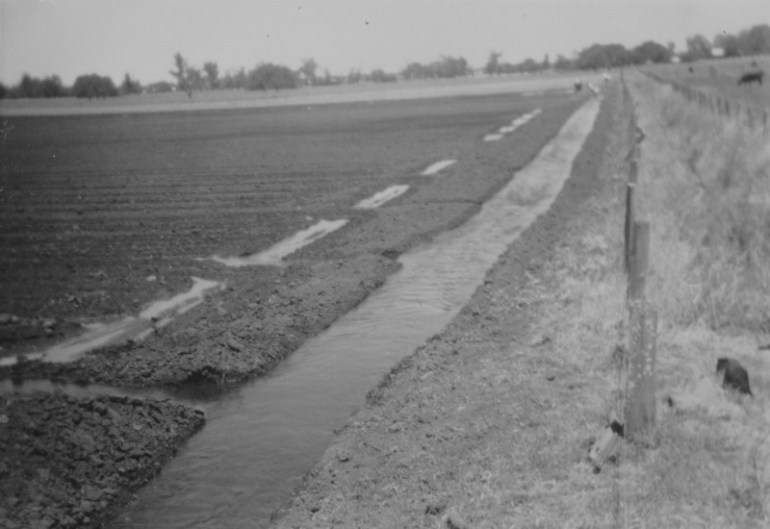
Furrows were ploughed into the paddocks to allow the water to spread.
Around 1935 the Public Works Department used a large steam driven dragline to dig the Victory drain at Waterloo and the Valiant at Burekup. Both were designed to drain off excessive water as some winters the rainfall reached 1000 millimetres. The area at Burekup was drained near Paradise on Dowdell’s Line through the Ladysmith Plains to the Collie River with Waterloo drained from Paradise down to Millars Creek.
Dethridge Wheels, invented in 1910 by hydraulic engineer John Stewart Dethridge, were installed to measure water flow, allowing volume to be managed and users charged.
With summer irrigation available, potato growing became wider spread in the Dardanup area.
The Government also introduced a milk quota system to supply fresh milk to the population all year round. Domenic Garbelini’s dairy was started in 1943 with eight milking cows he bought from his step father, Barney Panizza, and in 1949 he received his milk quota, supplying Browns Dairy at Brunswick Junction. Farmers were offered a 45-gallon milk quota which they would have to supply 365 days of the year. Many irrigation farms in the Shire of Dardanup owned milk quotas, with about sixty dairy farmers making a profitable living.
In the 21st Century, Harvey Water now manages agricultural water supply. Water is sourced from local dams through a licensing agreement with the Department of Water and Environmental Regulation and delivered through gravity flow in a network of channels and pipes to the Harvey, Waroona and Collie River districts. This 112,000 hectare footprint is known as the Harvey Water Irrigation Area.
Wellington Dam services the Collie River Irrigation District which stretches from Benger to Dardanup. It comprises over 16,000 hectacres, 267 kilometres of channels, serves over 470 farms and now occupies virtually all the irrigable land available. The main land uses are dairying, beef cattle and horticulture, particularly fruit growing.
An unexpected benefit of the irrigation infrastructure was the social value it provided the community. Families, old and young would swim in the channels and weirs of the scheme and picnics at the Old Quarry at Wellington Dam were a fixture of family life from the 1960s onward.

a fixture of life for families in the region during the 1960s and 1970s.
Source: Grace Truda Roper, State Library WA, slwa_b4567404_1
The installation of the wonderful mural during 2021-2022 on the Wellington Dam wall, painted by artist Guido Van Helten, gave the South West the distinction of being the location of one of the largest murals in the world. It is now enjoyed by residents and visitors alike.

Source: Vance Lee Thompson, State Library WA – slwa_b6574666_6
References:
- Memories of Dominic T Garbelini, provided by Tom Garbelini in 2025
- Flynn, Norm (editor); George Fee of Roseland – Dardanup – Diaries – 1886 – 1942 (2001), Dardanup, Western Australia, entry for 25 January 1935, p 461
- Burekup on the Henty (2000), by the People, published in Bunbury, Western Australia..
- Harvey Water – https://www.harveywater.com.au/, viewed 18 June 2025.
- Inherit – Department of Lands, Planning & Heritage (WA): https://inherit.dplh.wa.gov.au/public/inventory/printsinglerecord/88cb5aa9-a4a3-4435-bffe-05be94282fcf viewed 17 June 2025
- Collie River Valley website: https://collierivervalley.com.au/local-listings/wellington-dam/ viewed 18 June 2025
Newspapers:
- Southern Times (Bunbury, WA : 1888 – 1916), Thursday 1 December 1910, page 3
- Southern Times (Bunbury, WA : 1888 – 1916), Tuesday 5 March 1912, page 6
Images:
- The first overflow of the newly built Wellington Dam, c. 1933, Source: Bob Wight
- 1932-33 1932 – 33 – Digging the main irrigation channel from the weir at Burekup. Source: John Hards whose father Lou Hards was a ganger on this job. The location was known as Hards’ Cut.
- 1937 at Fir Park, Waterloo. Strike out for a channel. Source: Margaret Vinci
- Photograph of first watering at Fir Park, Source: Margaret Vinci (nee Hynes)
- c. 1960 – Head ditch for spreading irrigation water to paddocks – Dardanup. Source: Robert Garbelini
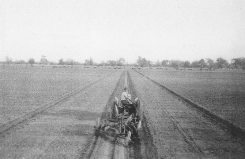
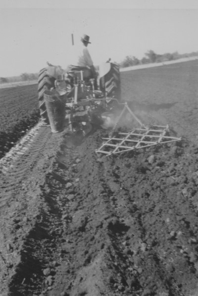
- c. 1960 – Domenic Garbelini planting and harrowing final row of potatoes. Source: Robert Garbelini
- Swimming in the channels at Waterloo. Source: Margaret Vinci
- The Old Quarry grounds, designed by John Oldham, above Wellington Dam, Source: Grace Truda Roper, State Library WA, slwa_b4567404_1
- Wellington Dam with the mural painted in 2021-2022 by artist Guido Van Helten. Source: Vance Lee Thompson, State Library WA – slwa_b6574666_6
The Dethridge Wheel

Situated in Eustace Fowler Park, opposite the Dardanup Post Office, is a Dethridge Wheel. Installed as a memorial to the system of flood irrigation, the wheel also stands as a reminder of the many dairy farms that once operated across the Dardanup Shire, with milking cows grazing on the green summer pastures.
The Dethridge Wheel was invented in 1910 by John Stewart Dethridge. John was a civil and hydraulic engineer. During a career spanning from1885 to 1926, he was instrumental in building many of the water supply and irrigation weirs and reservoirs across Victoria. With the development of irrigation, particularly flood and furrow irrigation systems, he realised the need for control, and accurate measurement, of water supplied to the individual farms.

The wheel consists of an open-ended steel cylinder with V-shaped vanes fixed to the outside. It is mounted in a concrete structure which holds it in place across the supply channel and directs water to the vanes. As water flows through the vanes, a counting device attached to the axle measures the volume of water passing through, according to the number of revolutions of the wheel.
The Dethridge Wheel is installed at the junction of a main irrigation scheme water supply channel, and the start of the on-farm water dispensing ‘head ditch’ channel that distributes water to individual paddocks.
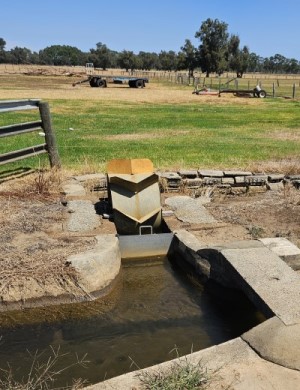
Correct placement in the channel is necessary for the most accurate measurement of the water. If installed correctly and moving parts are not worn, the accuracy can be within 7.5%. A slide consisting of a solid metal sheet that can be moved up and down, is installed near the Dethridge Wheel. This is used to block the water from flowing through the wheel and entering the farm channels when water application is not required. When flood irrigating pasture, the water is generally applied at 12-to-14-day intervals, depending on the daily summer evaporation rates.
As a low cost means of dispensing and measuring water from channels, the Dethridge Wheel was used extensively during the 20th Century in many countries, including Australia, Indonesia, Israel, India, Africa and the United States.
Many wheels are still in use around the world, and some can still be found around the Dardanup Shire. There is an operational Dethridge Wheel near the corner of Waterloo Road and Ferguson Road.
